Discouraging Travel on Commercial-Prohibited Streets
We sweat the details at RouteSmart. After 30+ years of refining our algorithms based on the input of hundreds of industry-leading clients, we believe our solutions are the best in the business for the industries we serve.
We sweat the details at RouteSmart. After 30+ years of refining our algorithms based on the input of hundreds of industry-leading clients, we believe our solutions are the best in the business for the industries we serve.
As a member of our Product Management Team, I work to improve the results of our solutions to ensure they provide the best possible results every time. This means faster answers, less rework for routers and dispatchers and more satisfied drivers.
One enhancement we have been working on is discouraging deadhead (non-productive) travel on prohibited streets. This feature minimizes the use of streets that don’t allow large commercial vehicles, unless there is required service on the street segment or streets are required to access the service streets. It can also be used to improve walking routes where some streets prohibit pedestrians.
This enhancement went live in RaaS in January 2019 and was introduced in RouteSmart for ArcGIS 2019.1. Clients must also be using HERE data from Q4 2018 or later.
The Commercial-Prohibited Streets feature leverages HERE data attributes to enhance solution intelligence. RouteSmart algorithms incorporate these attributes from HERE when solving the problem:
- Trucks – Is truck travel permitted along segments where a truck is defined as: “Heavy goods vehicles with more than two axles and designated for transporting goods?”
- Traffic – Is deadhead (non-productive) travel permitted along the segment?
- Pedestrian – Are pedestrians permitted to walk along the segment?
- Delivery – Are deliveries permitted along a segment?
All industries can benefit from these features. When enabled, RouteSmart for ArcGIS and RaaS will output:
- Travel paths that avoid travel on prohibited neighborhood streets
- Routes that exclude dedicated HOV lanes
- Safer and more accurate route plans that reflect local laws
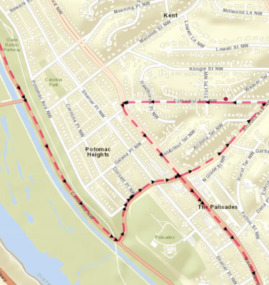
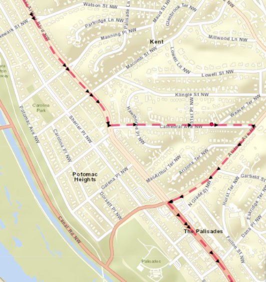
Here’s a real-world example from Washington, D.C.
Canal Road NW does not permit truck traffic. The map on the left shows the travel path with Commercial-Prohibited Streets turned off (this would not be permitted) and the map on the right shows the optimized path the truck should drive to avoid prohibited streets.
With the real world changing every day, our team and HERE do our best to keep up. As always, solution results require you to drive with caution. Your drivers must respect local signage and other laws.
If you would like to enable this feature, please contact our technical support team for assistance. It’s a great way for our clients to use their eXpert Services hours.


Ready to get started.
Get in touch with us.
Contact Us